"Our clients invest significant resources in geophysical surveys, and fluctuations in funding availability can significantly impact the industry's health."
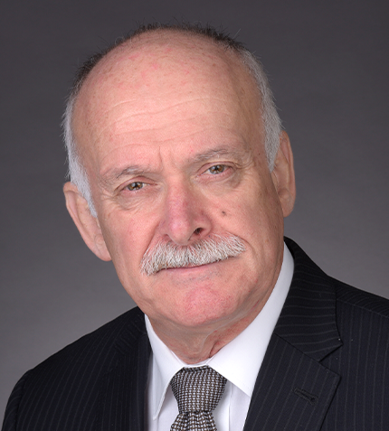
Howard Barrie
PRESIDENT, TERRAQUEST
Can you introduce Terraquest to our audience?
Terraquest is an airborne geophysical survey company. Our footprint extends globally, with projects executed across Africa and the mapping of substantial areas, including one-third of France, all of Puerto Rico and the Great Central Valley of California for the US Geological Survey.
Have you observed any recent trends in demand for your services?
Presently, we are experiencing a period where some sectors, notably North American gold exploration, are facing funding challenges, making it a difficult time for some juniors. On the other hand, the lithium miners and explorers are receiving significant funding and investment. We understand that the industry's requirements can shift, and we adapt our services accordingly. We work closely with consulting geophysicists, aligning our data collection with their specialized needs. The key to our success lies in our ability to cater to the specific demands of our clients, delivering the data they need.
What sets Terraquest apart from your competitors?
We take a meticulous approach to data processing and validation, ensuring that the data we deliver is not only accurate but also untouched by excessive computer smoothing. Our motto is "better data, better results," and this reflects our dedication to providing clients with pristine, unaltered geophysical data.
An essential aspect of our approach is that we do not directly interpret the data sets we collect. Instead, we collaborate closely with highly skilled consulting geologists and geophysicists who specialize in their particular areas. These experts may have their own proprietary software or deep industry knowledge, making them uniquely qualified to interpret the data effectively. Our role is to work in tandem with these geoscientists, ensuring they receive the precise data sets required for their consulting geophysics work. This collaborative process may involve multiple iterations, given that no two data sets are identical.
How do you approach a new project, and what is your internal process for tackling it?
We evaluate each request for proposal (RFP) by considering the level of planning and detail invested in it. For established major companies with well-defined objectives, our role is to execute the project as outlined in the RFP, ensuring that the data collected aligns with the client's goals.
Conversely, junior mining companies or projects with limited planning benefit from our guidance. In such cases, we provide insights into cutting-edge technologies and data processing methods that can enhance project outcomes. This client-centered approach is integral to our project execution process.
What are the biggest challenges facing your industry?
The primary challenge confronting the wider mineral exploration industry is funding. Our clients often invest significant resources in geophysical surveys, and fluctuations in funding availability can significantly impact the industry's health. Additionally, the industry is currently grappling with a shortage of qualified professionals willing to work in remote and challenging locations. This shift in workforce dynamics contrasts with the earlier days of the industry when fieldwork was more appealing to younger talent.
How do you see the role of drones evolving in the airborne geophysical survey space?
Drones are poised to play an increasingly significant role in the airborne geophysical survey space. Their key advantage lies in their ability to capture high-resolution data in areas that are challenging for traditional aircraft. These areas may include rugged, mountainous terrain, which is often inaccessible or expensive to survey using conventional means. Drones offer agility, cost-effectiveness, and access to locations that would be otherwise difficult to reach. Regulatory bodies, such as Transport Canada and the FAA, are actively developing protocols to permit beyond-line-of-sight drone operations for airborne geophysical surveys. This regulatory progress indicates that, in the next two to three years, drones will likely become even more prominent in the industry.
Can you share your plans and expectations for Terraquest in the coming years?
Terraquest is on the brink of significant changes and collaborations. We anticipate engaging in new projects across different parts of the world in partnership with new collaborators. We are actively working on these initiatives and expect to make announcements soon. These changes will set the course for Terraquest's next chapter. Our aim is to remain at the forefront of the geophysical survey industry, adapting to the evolving needs of our clients and the industry in order to provide better data, and better results.
INTERVIEWS MORE INTERVIEWS


RECENT PUBLICATIONS

USA Mining 2025-26 pre-release is a snapshot capturing insights from over 70 executives and decision-makers across the value chain and from coast to coast, sharing not only how the industry is changing, but also where it is heading next.
MORE PREVIOUSLY PUBLISHED
MACIG
SUBSCRIBE TO OUR NEWSLETTER

- Get GBR content delivered to your inbox
- Receive industry based news
- Completely free, e-mail only